This article was born out of concern for the future of our cities, especially Tallinn. It appears to me, as an outside observer, that many large-scale projects in the capital are carried out without any consideration for an overall strategic vision for the city. Although some of the blame can also be placed on the lack of a strong and clear strategic vision for Tallinn, of late, notable progress has recently been made to remedy this situation.
What should be regarded as a major problem is the opaque decision-making process. Many planning decisions which are highly relevant to the city’s strategic development are suggestive of inadequate funding of the city’s Urban Planning Department and pressure from other interest groups and government agencies. The actual involvement of the city’s denizens and consideration of their interests in decision making is more often than not lacking. Although, the true problem may lie not so much in the fact that the local people are prevented from having their full say in every process, but in that the true reasons behind the decisions are kept hidden.
If the reasons which are given for the planning decisions are such that cannot be understood by the people, no meaningful discussion and debate will be possible even at the most elementary level, sparking weird and at times irrelevant protest on the part of the city populace who feel that they are being left completely in the dark. I sincerely hope that the decisions are backed by data and the crux of the problem simply lies in miscommunication. However, the suspicion lingers that many decisions are solely intuitive, shaped by political considerations not said aloud and the gut feeling of the decision-makers.
All the buzz generated by the concepts of ‘smart city’ and ‘big data’ of late inevitably points to the question—how can the data be better harnessed in the service of city planning? An enormous amount of urban data that can be mined already exists. To a very large extent, these data are produced by ourselves when we move around the city and use location-aware smart applications, make payments using a bank card, swipe the ‘green card’ to validate our ride on a city bus, purchase or sell real estate, apply for a building or logging permit, or simply pass the sensor of a people counter in a shopping centre. Deep analysis of these data can lead to a better understanding of urban processes, which contributes to carefully considered planning and is therefore a prerequisite for the emergence of a better city.
Data-driven Tallinn
Although a small part of the data collected in the city is made public via official applications, unfortunately, for planners, academic researchers, real estate developers and general public, most of the data remains out of reach. If the data are to be of any actual use in improving our understanding of the workings of the city, they should all be available to the public and accessible via APIs (Application Programming Interface), with as little restrictions and exceptions as possible. By combining data from multiple sources, it is possible to create new applications that are capable of elevating the process of making city planning decisions to an entirely new level.
No doubt, once such vast open data resources are made available via APIs, the market of smart applications will be flooded with new products in an instant. For example, in the USA the explosion in the availability of urban planning data resources has made possible the development of an application called Zonar, which assimilates GIS data, property records and zoning regulations to predict and analyse development capacity for any land parcel.1 As we can see, sometimes such applications can grow into profitable undertakings, contributing to the economy at both municipal and national level. Yet what is perhaps even more important is the opportunity that lies there for the denizens of the city to create themselves applications which can provide insight into various (including planning-related) processes in the city. One such application is tallinnraiub.ee which was created in summer 2017 and which uses the public database accessible at https://raie.tallinn.ee/open_raie.php. Indeed, such a community initiatve is only possible thanks due to the availability of open data.
Open data also importantly provides the means for people to spontaneously scrutinise the planning decisions and processes. The public sector is morally obligated to ensure free access to the data that are collected using taxpayers’ money. The Estonian Green Paper on the Publication of Machine Readable Public Data, created at the initiative of the Estonian Government, begins with a clear statement that “the freedom of information is one of the fundamental freedoms of democracies”. Yet, the public sector itself is more often than not disinterested in opening up the data for the public, or lacks the necessary technical capacity or resources. As taxpayers, we then must demand ourselves what we are rightfully entitled to! The United Kingdom has already seen several open data campaigns, such as Guardian Technology’s Free Our Data which called upon the public authorities to make available the data collected with taxpayers’ money. Estonia has also launched its open data portal at https://opendata.riik.ee, but its content is currently rather meagre and no planning and building-related data that would be relevant for the city’s development can be found there.
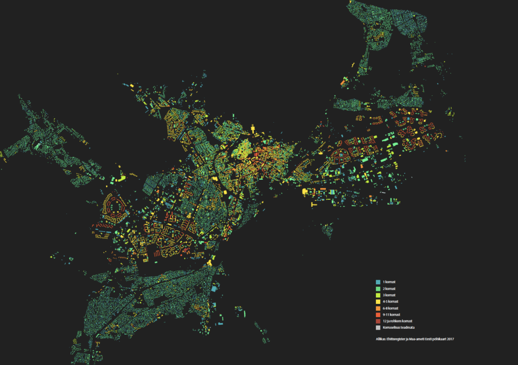
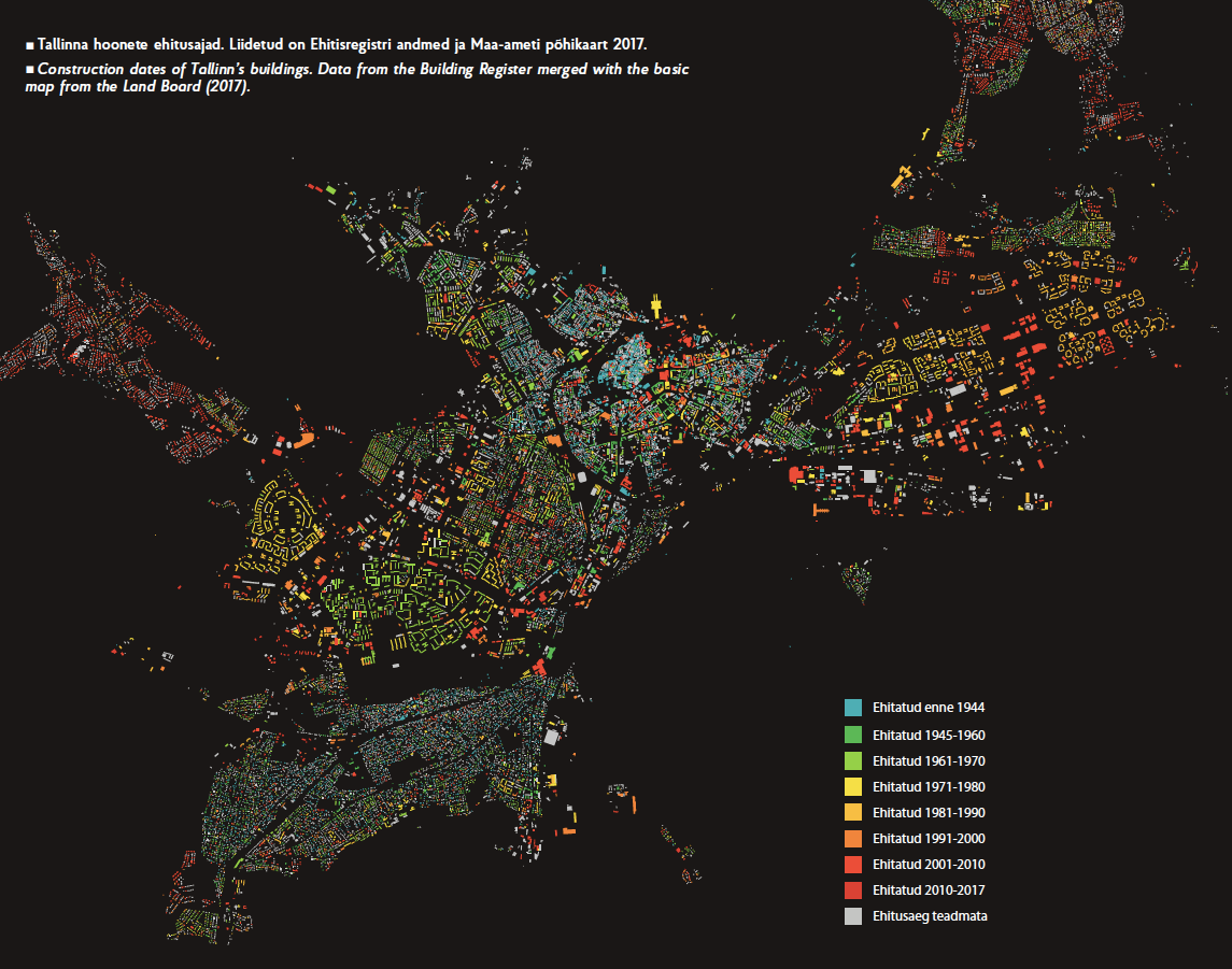
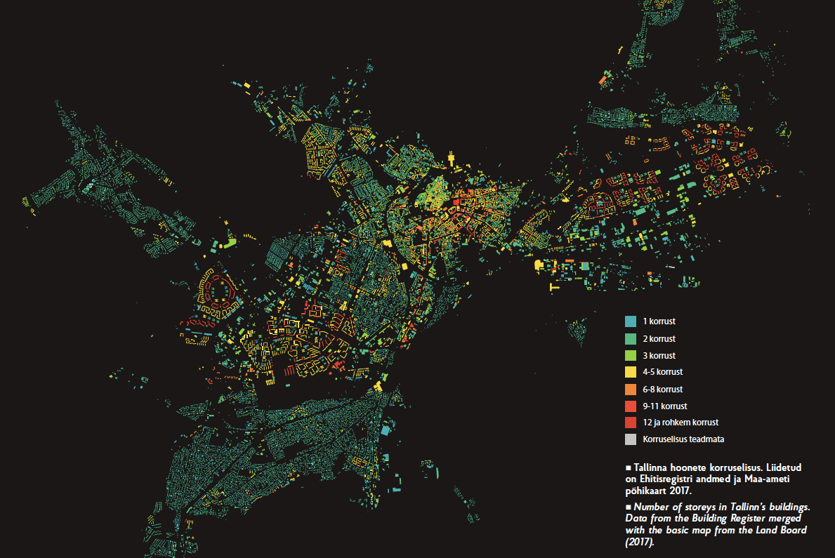
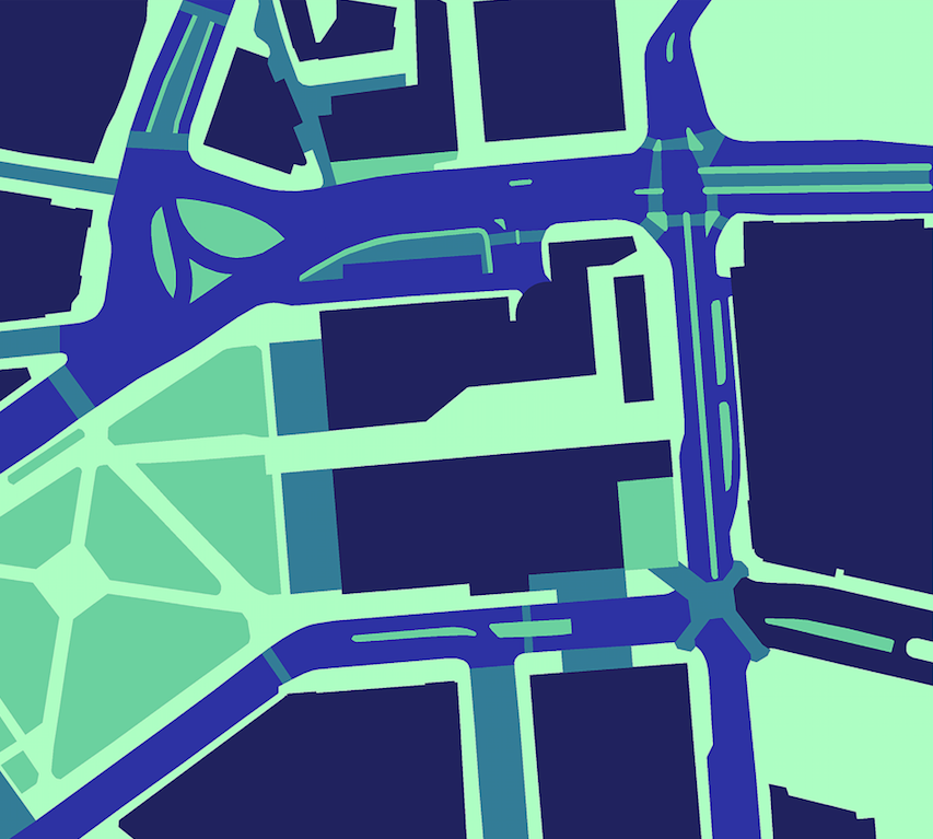
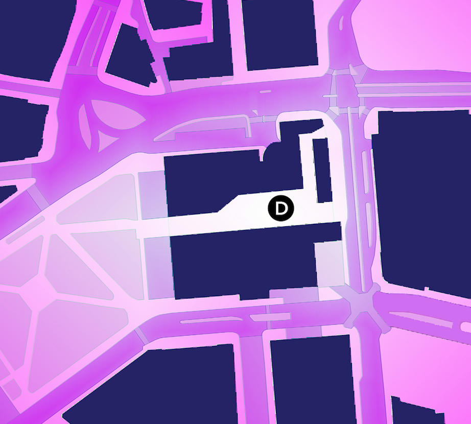
The functioning of the city is intimately intertwined with the movement of people and urban mobility in general. It is what the public transport plans, traffic managements schemes and the design of the city’s street network should and must be based on. The amount and complexity of movements even in a city of the size of Tallinn is staggering. To understand it, a mere look at the collected data is of no use, one has to resort to the tools of computation. So far, Tallinn has used computational models to simulate the effect of building new roads on traffic patterns. By now, with the assistance of the Urban Planning Department, a study of pedestrian movement in the city centre, including the creation of computational simulation model, has been completed.2 It is a telling fact that one of the most laborious tasks involved in the study was the acquisition of count data for pedestrians and public transport passengers.
For instance, the public transport data that have been generated since the introduction of the ‘green card’ unified ticket system in Tallinn currently remain unavailable to the general public. The need for these data does exist and, once available, applications would surely follow soon—for better travel planning, optimisation of public transport, assessment of public transport demand or, why not, for finding suitable areas for new development projects. As with all other data relating to identifiable individual persons, the green card data must be handled in observance of the principles of personal data protection. The authorities in charge of city planning, on their part, should ensure that as much of the collected data as possible is made accessible for all parties involved or affected by planning decisions.
Fear of the emergence of cybernetic city
I do hope that my last turn of thought will help to assuage some of the fears which, for example, have been expressed in Maroš Krivý’s critique of cybernetic urbanism.3 According to him, the idea of a smart city is incompatible with the informal and spontaneous character of the city and reproduces social inequalities. Yet, one would presume that the use of open data rather stimulates the increase in spontaneous, unofficial, community-based or private initiatives or events in the city. Freely available information rather adds to the general freedom of the citizens than subtracts from it. It goes without saying that the availability of open data contributes to the transparency of decision-making processes. At the same time, it must be conceded that inequality will increase if data is controlled by a single interest group, yet this is primarily of concern in the case of restricted access data.
A cybernetic city, envisioned as a rigidly controlled and purely algorithm-driven automaton, remains an improbable dystopia. The attainment of the precision of a well-oiled machine in the workings of a city becomes too complicated. Urban planner and geographer Michael Batty4 points out that, in London, real time adjustment of the public transport timetables to match the actual demand for public transport is near impossible, since the source data have different structure, they are stored in separate databases and their handling is subject to strict privacy protection requirements. In contrast to the cybernetic machine-city, a smart future city could be conceived as an aggregation of dynamically interrelated processes.
Regardless of the complexity and complications involved, the open public data holds a true potential for the discovery of new patterns in the city, finding new ways of understanding of what goes on in the city and harnessing the knowledge so obtained for the benefit of the individual, community or business, all in all leading towards an increasingly multi-layered, intertwined and prosperous city. ‘Big data’ may appear like yet another buzzword, but, in fact, big data has been a reality for quite some time already. The decision-makers in charge of shaping our urban space bear the responsibility to learn from the data and, accordingly, build a better city for us.

RENEE PUUSEPP is an architect and technology entrepreneur. He holds the position of Senior Research Fellow at the Estonian Academy of Arts where he leads the research on pedestrian movement at the 3D Lab of the Faculty of Architecture and supervises the Master’s students in architecture and urbanism. Outside the Academy, he develops a technology for mass adaptation of buildings and provides his services to architecture firms.
2 Puusepp, R. et al. “Simulating pedestrian movement”. In Humanizing Digital Reality, 1 -12. Springer (2017). (in press)
3 Krivý, M. “Towards a critique of cybernetic urbanism: The smart city and the society of control”. Planning Theory (2016).
4 Batty, M. “Big data and the city”. Built Environment 42 (2016): 321–337.
Simulation of pedestrian movement in Tallinn
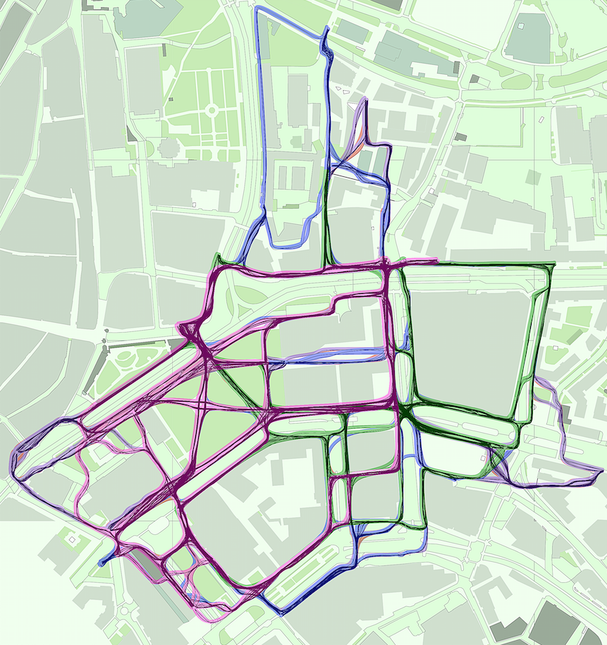
The aim of our work is the creation of a model that would predict how urban design influences pedestrian movement. A study conducted at the 3D Lab of the Faculty of Architecture of the Estonian Academy of Arts confirms that the pedestrian movement can be successfully simulated with an agent-based computational model.
The area we observed was the city centre of Tallinn where, as a first step, we mapped the movements of pedestrians—using smart devices with GPS capability, we recorded the trajectories of more than 700 pedestrians and later transferred these to a GIS programme. Next, we created an agent-based simulation model to imitate the movement of pedestrians. As simulation input, we assigned to all pedestrian-accessible areas values which we used to calculate the so-called cognitivedistances which, on their turn, were used by simulated agents when moving from point A to point B in the city. We claim that such simulation models, calibrated with empirical observation data, can be used by urban planners to play out and evaluate different planning scenarios.
Agent-based models are not a novelty in urban space analysis—perhaps the best known are the Space Syntax analysis methods. For instance, Penn and Turner1 have employed precalculated visibility graphs where the simulated agents have no pre-existing knowledge of the layout of the urban space whatsoever—in that respect, they are more like random walkers who make their decisions on the spot.2 This kind of behaviour, however, in reality is rather uncommon. Unlike the Space Syntax method, we assume that the agents are aware of the shortest possible route between their starting point and destination.
At the same time, an agent need not always choose the shortest possible route, since the agent’s movement decisions are influenced by several properties of the street space. For instance, wider pavements, less noise, sunnier and greener surroundings and other activity options which certain streets and spaces provide. The proponents of different methods, including the researchers who use Space Syntax, claim that the simulation of pedestrian movement can be successfully accomplished also without context. However, in our approach, as we regard this as an important precondition, we assume that the pedestrian movement is influenced by sociocultural background and therefore differs by country and city.
Consequently, we think it is important to observe the movement of pedestrians on the site and collect data for the adjustment of the simulation model. We calibrate and modify the model until the choices of the simulated agents overlap with those of the observed pedestrians in urban space.

1 Penn, A., Turner, A. “Space Layout Affects Search Efficiency for Agents with Vision”. In 4th International Space Syntax Symposium, 9.1–9.16. (2003).
2 Batty, M. “Agent-based Pedestrian Modelling”. In Advanced Spatial Analysis: The CASA Book of GIS, edited by P. A. Longley and M. Batty, 81–108. New York: ESRI, 2003.
PUBLISHED: Maja 91 (autumn 2017) with main topic Shared Space